
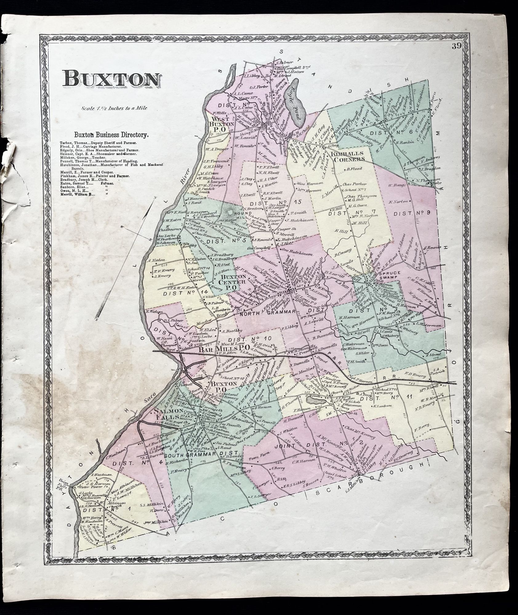
1872 Hand-Colored Street Map of Buxton, Maine with property owner names
Philadelphia, Pa: Sanford, Everts & Co., 1872. 1st Edition. Folio. Very Good. Item #15735
A beautiful 1872 hand-colored map of Buxton, Maine in York County, ME
This map includes property owner names.
"The first permanent settlement commenced in fall of 1750 near Salmon Falls, which was within protection of the stockaded blockhouse and trading post built in 1728 a half mile below Union Falls in present-day Dayton. Amos Chase was one of the pioneers of the town, and his daughter was said to be the first white child born in Buxton. He was a prominent figure in the area, one of the largest taxpayers, and was the first deacon of the Congregational Church in Pepperellborough (present-day Saco, ME). The first schoolhouse in Buxton was established in 1761 by Rev. Silas Moody. Narragansett Number 1 was incorporated in 1772 as Buxton. It was named by its minister, Rev. Paul Coffin for the spa town of Buxton in Derbyshire, England, for unknown reasons. Buxton, England is often incorrectly cited as the home of his ancestors, but that was Brixton as noted on page 7 of the cited source(2).
Settlers found the land generally level and suited for farming. Chief crops were corn, potatoes and hay. Buxton also provided excellent water power sites. The first sawmill was on the Little River, a tributary of the Presumpscot River. A gristmill called Bog Mill was built at the outlet of Bonny Eagle Pond. The biggest mills, however, were located at the series of falls on the Saco River. Salmon Falls had sawmills capable of turning out four million feet of lumber annually. Bar Mills had gristmills and a box mill. Moderation Falls in West Buxton had sawmills, heading mills and woolen textile mills which produced about 936,000 yards of cloth annually. Buxton's mill town prosperity left behind fine architecture. Listed on the National Register of Historic Places are Elden's Store, the Buxton Powder House, the First Congregational Church, Royal Brewster House and Salmon Falls (East) Historic District."
This map measures 16" X 14" and is perfect for framing and display!
#2D-009.
Price: $75.00